Cartografiando Gaza
Cartografiando Gaza (: Architecture, urbanism and technology in the Israel-Palestine conflict) fue iniciado en el Taller de invierno en la Escuela de Arquitectura de Alicante 29-30-31 Enero 2009
Este trabajo recoge un catálogo de mapas, software y vídeos coordinados de forma narrativa usando tecnologías avanzadas de descripción del espacio (GIS, Software, Modelado 3D) mostrando aspectos que no serían evidentes en una primera lectura. Pueden ser extrapolados a territorios y contextos de paz sujetos a tensiones y transformaciones en que la arquitectura y el urbanismo tengan una importancia relevante.
Development: Architecture, urbanism and technology in the Israel-Palestine conflict (including arguments by Eyal Weizman, Alessandro Petti, Giorgio Agamben, Naomi Klein). These authors and researchers understand 1/ that urbanism and architecture have a prominent role in the conflict, and 2/ Israel-Palestine is not an exception but rather a laboratory for contemporary urbanism based on enclaves and islands, connection-exclusion, control society, etc.
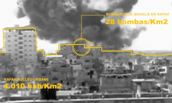
Gaza in particular and urban, architectural, technological features of the conflict/ war going on right now.
Exercise proposal Based upon this information, and other that can be supplied in advance, students, organized in groups will make a conceptual proposal of counter-devices; that is spatial, architectural, urban, technological devices that “hack” the above mentioned concepts to promote/ enable resistance, peace, cooperation, dialogue, communication, rights, liberties, international support…